Illinois Tax Maps
| Coverage | uFIND Bubble | |
 |
 |
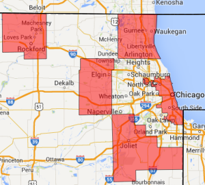
Illinois Tax Map coverage consists of five different sources across 7 individual layers. Place a Location of Interest (LOI) within the coverage shown above to access the PDF tax maps.
Click Here To Try This Layer| Sources: | Multiple (See Below) |
| Updated: | 10/13/2017 |
| Records: | 21,175 |
Data Info
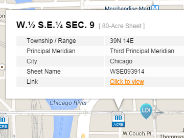
City of Chicago 80-Acre Sheets
This layer represents the central location of every available 80-acre sheet provided by the City of Chicago. Positions are derived from the Public Land Survey System. These points are to be used as reference material to acquire desired 80-acre sheets and not meant to be used for analysis. User must be logged in to his or her uGRIDD account to access available URLs.
Kane County's tax map data on uGRIDD consists of two layers: one polygonal for master sheets and one point for the available detail sheets.
Each tax map in this point layer represents one quarter-quarter-section of Lake County. The points on uFIND mark centroid locations for each quarter-quarter-section.
Each tax map in this point layer represents one half of one quarter-section of Will County. The points on uFIND mark centroid locations for each 80-acre survey area.
Winnebago County's tax map data on uGRIDD consists of two layers: one polygonal for master sheets and one point for the available detail sheets. Each polygon master sheet consists of four survey sections and the points show centroid locations of quarter-sections.