LiDAR2Map, View and Measure LiDAR Data In Any Browser
Dear uGRIDD users:
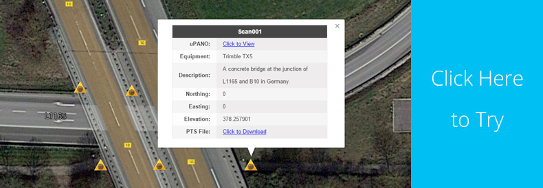
uGRIDD is excited to announce LiDAR2Map, a new uSHOW tool that displays registered LiDAR data collected by any commercial laser scanner or mobile LiDAR system in your web browser or mobile device.
LiDAR2Map produces panorama views at the given vantage points from LiDAR data and displays them on an interactive map. Users can access the map page from a unique URL shared by the publisher then view the panoramas in uPANO, a built-in proprietary viewer. Users can also measure distances between any two points and extract single point XYZ coordinates while viewing the panoramas. uPANO provides users the flexibility to view and measure LiDAR data in any browser, including those on mobile phones and tablets. The raw and/or processed LiDAR data sets, in any format, can also be hosted on the uGRIDD Cloud for download at the user’s convenience.
As with all uSHOW products, pricing is very reasonable. For example, a publisher can process and share up to 25 LiDAR scans for approximately $100 per year, depending upon the size of the LiDAR data sets. The publisher can renew the webpage annually, as needed.
LiDAR2Map is set to be released mid-May 2015, supporting PTS data. LAS and E57 support are in development and coming soon!
Where to find uGRIDD in June:

Las Vegas, Nevada