Lightning Speed to Find NGS Datasheets !
NGS Monument Datasheets
| Source: | National Geodetic Survey |
|---|---|
| Updated: | 01/2014 or later |
| Records: | Approximately 700,000 |
Feature Layer:
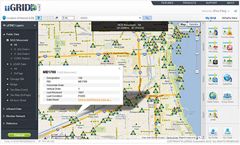
To find NGS data sheets for a project, enter your LOI (Location of Interest) on the map, then search within a radius. The found NGS monuments will be displayed on the map. A URL in the pop-up bubble links users to the monument attributes and the DATASHEET provided on the NGS website for the most current information. This layer was developed by downloading the state-based shapefiles from the NGS website. Users can choose to search horizontal or vertical 2nd order or better monuments, or Continuously Operating Reference Stations (CORS). This dataset is updated on a monthly basis on www.uGRIDD.com.How to use uFIND:
- Go to www.uGRIDD.com;
- Click on LOI (Location of Interest) and set it on the map;
- Select a desired search radius;
- Pick a layer on the left panel.
LOI can be a point, line or shape.
* you may need a free uGRIDD account to access the detail imformation page.
* you may need a free uGRIDD account to access the detail imformation page.