 |
uSHOW |
uSHOW is a collection of time saving tools that process specific data to be viewed on a map. The deliverable comes in the form of a unique URL. The URL can be protected by uGRIDD user name and password. Users can view the map via email invitation with the URL and invitation code. The tools also provide HTML codes that can be inserted into your website.
Includes:

Scan2Map
This tool allows terrestrial laser scanning service providers to publish their scan data so that clients can visualize the data in their web browsers. Currently, the tool supports Leica TruView, Trimble RealWorks, and Riegl RiSCAN data. This tool replaces previously released TruView2Map and TScan2Map. To use Scan2Map, the service provider needs to know the local projection to which the scan data is registered. Vantage points are automatically extracted from the data set(s) and overlaid on an interactive map based on the scanner's setup position. uGRIDD plans to expand the capability to support additional major terrestrial laser scanner brands.Online Example:
Video Demonstration:

LiDAR2Map
This tool allows users to visualize registered LiDAR data collected by any commercial laser scanner or mobile LiDAR system in your web browser or mobile device. LiDAR2Map produces panorama views at the given vantage points from LiDAR data and displays them on an interactive map. Users can access the map page from a unique URL shared by the publisher then view the panoramas in uPANO, a built-in proprietary viewer. Users can also measure distances between any two points and extract single point XYZ coordinates while viewing the panoramas.Online Example:
Video Demonstration:
Demo data:

Aerial4Map
This tool overlays aerial images and/or orthophotos on an interactive map. The aerial images and orthophotos need to have georeference parameters, either embedded into the image files or saved in separate files, such as a world file. The parameters may also be keyed into the interface. Multiple images can be processed at once with the last entered image showing on the top.Online Example:
Video Demonstration:
Demo data:

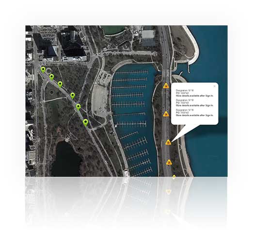
Data2Map
This tool processes a data set with geolocations. The geolocation data may be in WGS 84, other local grids, or user defined grid system is also supported. The definition requires at least two points (2 pairs of NE coordinates) that have WGS 84 coordinates (lat and lon) or other known local grid system, i.e. State Plane Coordinate (SPC) in US. The data set may include text, URLs and line coding to present icons, lines (and line strings) and shapes on the map.Online Example:
Video Demonstration:

KML2Map
This tool takes a KML or KMZ file and overlays it on an interactive map.Online Example:
Video Demonstration:
Demo data:

Photo2Map
This tool takes multiple photos and generates an interactive album with a map.Online Example:
Video Demonstration:
Demo data:

SHP2Map
This tool takes a zip file containing .shp, .dbf, and .prj files and then overlays it on an interactive map.Online Example:
Video Demonstration:
Demo data:

Video2Map
This tool takes videos uploaded to Youtube, along with a time-location text file, and generates a web page where the Video and Map work interactively.Online Example:
Video Demonstration:
Demo data: